IGIS is in the news for the development and release of the Wild Pig Damage App! The app was recently higlighted by Julia Mitric, Food And Sustainability Reporter with Capital Public Radio.
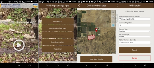
Description of the App: The UC ANR's University of California Cooperative Extension and Informatics and GIS Program have developed a GIS-based mobile application for Apple and Android devices that will collect wild pig damage on range, forest and agricultural lands over time. By taking at least three locations the app will map acreage and geographic location of wild pig damage reported by the users. Cell service at the site is not required to collect data.
The data will be uploaded to a UC ANR server for use by the UC advisors and the specialist that created the app so they may analyze and report data at a county, region, state, national or international level. Private property and user identities are blocked from the general public to maintain the privacy of the users. Public land managers can also use the app. The first efforts are focused on California.
Potential users include ranchers, farmers, forest land owners, managers, and agency personnel such as UCCE Advisors, NRCS, Wildlife Services, etc. In addition, citizen scientists could also report damage on public lands or on private lands if they have access permission by the land owner.
The screen shots below illustrate how the app appears on an Android device
