Interested in knowing how people are using their geospatial skills in the era of COVID-19?
Last week, Harvard hosted a 10-panelist webinar (Center for Geographic Analysis Virtual Forum: Responding to the COVID-19 Pandemic with Geospatial Research and Applications) in which experts explored real-time datasets, displayed transmission models, and discussed data ethics of the current pandemic.
Innovative uses of datasets (such as mobile phone data and social media Tweets) exemplified how we can instantaneously map the spread of this disease at very high temporal and spatial scales. Yet, as many geospatial fanatics and drone pilots know, with high resolution comes high risk (of privacy concerns, in this case).
Data privacy emerged as a recurring theme throughout this webinar. Several panelists discussed confidentiality issues of pandemic mapping, which involve the spatial resolution at which data are analyzed – at the individual level or aggregated to a larger and more anonymized level: a scale at which houses, faces, and identities cannot be recognized in detail.
Dr. Caroline Buckee (Harvard), who has been building a research network in collaboration with data companies to aggregate, anonymize, and analyze COVID-19 cellular phone data, explained why the data she analyzes are disseminated at the county level, instead of at the house or neighborhood level. One reason for this is that we would not want punitive action to take place against specific neighborhoods or households if they are not following mandates such as the shelter-in-place policy, because we don't know if these individuals are attending work or are performing essential tasks. It is important that the data we share does not result in discrimination.
Dr. Doug Richardson (Harvard) echoed these sentiments and provided information on a platform he is developing to promote data security and confidentiality: Geospatial Virtual Data Enclave (GVDE). Ethical and security standards embedded into this portal can help ameliorate issues of data confidentiality.
Another theme that was brought to light in this webinar was how narratives can become lost in COVID-19 geospatial data. Dr. Mei-Po Kwan (Chinese University of Hong Kong) mentioned how every dot on the map has a story – and these stories are steeped in inequity and inequality. Dr. Buckee reminded us that each transmission has important geographic context, and considering different risk factors (such as age and socioeconomic status) and covariates (such as population density) are key to interpreting these data. Finally, Dr. Este Geraghty (Esri) introduced several resources that Esri provides to incorporate and honor the stories of those who have battled against the virus (https://coronavirus-resources.esri.com/pages/resources).
Below are notes on some of the methodologies and resources discussed in the webinar.
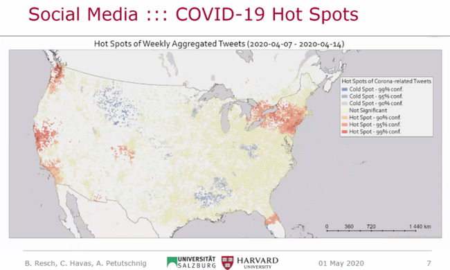
Twitter COVID-19 Hot Spots (April 7-14, 2020) created using the Twitter geo-search API (spatial query, no semantic query), and the Getis Ord Gi* function (hot spot analysis) on the attribute: #relevantTweets/#allTweets (per cell). The methodology (semantic machine learning) is described in this publication: https://www.tandfonline.com/doi/full/10.1080/15230406.2017.1356242.
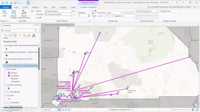
A location / allocation model in Esri's ArcGIS Pro for finding optimal testing sites, treatment sites, and food distribution sites during the pandemic in San Bernardino County. This model determines the population demand by creating a risk surface (including transmission, personal susceptibility, exposure, socioeconomic factors), and then calculates optimal locations (layers: road network data, risk surfaces, supply chain constraints for staffing facilities / administering tests).
Resources:
- Esri COVID-19 resources: https://coronavirus-resources.esri.com/pages/resources
- ArcGIS implementation of the University of Pennsylvania's COVID-19 Hospital Impact Model for Epidemics (CHIME): https://www.arcgis.com/home/item.html?id=37ad6eb0d1034cd58844314a9b305de2
- COVID-19 Spatiotemporal Rapid Response Gateway: https://covid-19.stcenter.net/
- COVID-19-related big-data analytics demo by Todd Mostak of OmniSci Technologies portraying interactive exploration of 16 billion rows of location data from mobile phones, from their cell phone partner X-Mode: https://youtu.be/Oeg3jF5xs6o?t=147
In summary, this was a very informative seminar that acknowledged several critical topics in geospatial data analysis, highlighting strengths of data sources and methodologies, along with concerns and shortcomings in the current state of pandemic mapping.

