During this coronavirus lock down, IGIS has set out to revamp its data infrastructure to address our growing needs for big data storage and management moving forward. In particular, over the past few years we have accumulated over a dozen terabytes of drone data and associated mapping products, constituting tens of thousands of project files, and the quantity of this data is only expected to keep growing. Typically this drone data has been processed on a number of local desktop computers, and then backed up onto RAID hard drives or the cloud for cold storage; however, this is far from ideal in terms of consistent organization, versioning and ease of distribution.
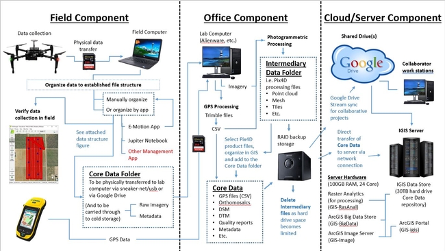
As a solution to the problem, IGIS purchased a web server, equipped with multiple virtual machines (for processing, analysis and web services) along with a 30TB RAID data store/repository. The repository was networked to our various IGIS computers and RAID storage devices, so that all of our drone data could be transferred over to it. After much consideration, we settled on a standardized file structure, which could accommodate both datasets from past and future drone projects, with room for growth as needed. A python script was written to automatically generate this file structure, with some metadata inputs for each project, and our previous projects' data were then moved into their appropriate slots in the new structure, while jettisoning unwanted intermediary processing files; freeing up a ton of storage space. It would be correct to assume that this process of moving data was quite time consuming. However, moving forward, it will be easy to automatically set up our projects' file structures right from the inception of every new project, beginning with running the python script in ArcGIS Pro's Jupyter Notebook utility in the field, to eventually be delivered to the server repository down the pipeline, in a nicely organized package (similar to what we would provide to our non-IGIS project collaborators).
That alone is a big step in the right direction, but it gets better. Because all of this data is now in a standardized file structure, with standardized folder naming conventions, scripting our ArcGIS portal to automatically connect with the data via the imager server was only a small step away. With this complete, now any IGIS team member can access our entire post-processed, GIS-ready, drone data inventory of layers via ArcGIS Online or ArcGIS Pro.
Ultimately this has been a big leap forward, in terms of IGIS's informatics infrastructure; to compliment our significantly evolved pipeline for drone data collection and processing, depicted below.
