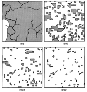
Forest cover in Cadiz Township, Wisconsin: 1831, 1882, 1902, 1950It is graduation season around Berkeley, which means some time to look forward to the future, and take stock of the past. For me, taking stock of the past happened unexpectedly today when, in cleaning up my desk, I found a print-out of one of Tim De Chant's earlier blog posts from Per Square Mile entitled "The map that started it all" about his early fascination with this map, from John T. Curtis, published in Man's Role in Changing the Face of the Earth. Tim is now senior digital editor at NOVA and editor of NOVA Next, which is very cool.
Tim describes the map documenting a transition from a wild Wisconsin dominated by a deciduous forest to a landscape in which the remaining woodlots are barely visible. This was proto-GIS, as Curtis recreated the scenes from survey data and his own observations, painstakingly piecing together handwritten records of the six-by-six mile township.
This is such a nice entry, and reminds me of many things: past students now gone on to great things, past times reading Man's Role in Changing the Face of the Earth in the 1980s in McCone Hall for an exam in Hooson's class, and my own nascent interest in all things landscape palimpsesty and patterny.
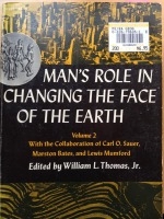
Here is my copy (at right) of the venerable tome, Volume 2, complete with its ridiculous price tag: $6.95!
I've always been in love with maps, and am fortunate now that my career allows me to learn about them and their uses daily. Thanks Tim for the reminder!

